HIGHLAND RIM
6 Burgess Falls Natural Area (Window Cliff)
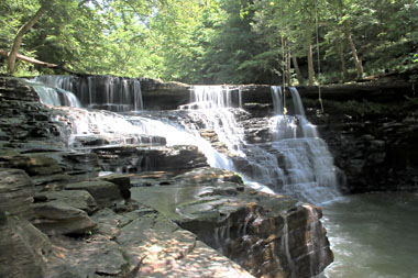
Window Cliff Falls (u)
Rating: * * *
Magnitude: 56
Form: block
Access: trail
Distance: 2.2 miles
Difficulty: hard
Watershed: large
USGS Map: Burgess Falls (1986 ns)
Govt Trail Map: Window Cliffs State Natural Area
Page in Guidebook: NEW ENTRY!
cross-reference
Description: Cane Creek tumbles 30 to 40 feet over a 35 to 50-foot wide
horseshoe-shaped escarpment. Now publicly assessible with the
opening on April 7, 2017 of Window Cliffs State Natural Area.
Directions: By all online accounts, hiking to this entry is difficult and recommended only for sturdy, experienced outdoor enthusiasts.
(I was fortunate several years ago to have had permission to pass through private property in order to document the waterfall.)
From the signed entrance for Burgess Falls Natural Area (described on page 260 of the guidebook), drive 3.6 miles north along SR 135
and turn left (west) upon Cookeville Boatdock Road. Proceed 4.1 miles, then turn left on Ball Hill Road. Bear right in 1.2 miles where
the way turns into Old Cane Creek Road. The trailhead will be met after 0.4 miles at the road's end. Embark upon the trail, which will
have ten stream crossings along the 2.2 miles to the falls. Some of the fords across Cane Creek may be knee-high or more.
During moist periods, Oxbow Falls (u), can be seen dropping over a cliff from an unnamed drainage 0.1 mile upstream and
to the right of this entry. This natural area is administered by Burgess Falls State Park and Natural Area; the state park designation
has been recently added by the Tennessee Department of Environment and Conservation.
Go To: Previous Entry
Next Section | Previous Section
Next Chapter | Previous Chapter
Chapter Contents
Master Table of Contents
Index of this Chapter
Master Index
Index by Chapter
Updates
New Entries
Purchase the Guidebook
Copyright 2014 by Gregory A. Plumb