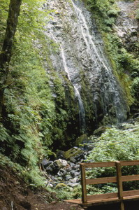
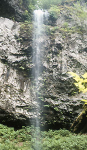
 Clarence Creek Falls (u)
Rating: **
Form: horsetail
Magnitude: 27
Access: auto (page 237)
USGS Map: Blaine (1984 nl)
Edition: 1st
 Clarence Creek Falls (u)
Rating: **
Form: horsetail
Magnitude: 27
Access: auto (page 237)
USGS Map: Blaine (1984 nl)
Edition: 1st

 Niagara Falls and Pheasant Creek Falls
Rating: ***
Form: segmented
Magnitude: 26 (l)
Access: trail (page 237)
USGS Map: Niagara Creek (1979 ns)
Edition: 2nd
More
Click Here for Alder Glen Falls, USGS Dovre Peak (1984 ns)
Click Here for Slide Mountain Falls (u), USGS Fairdale (1979 nl) NEW!
Output the CLICK HERE page to match your hardcopy book by changing your printer settings to 9" x 5 3/4".
Others
The U.S. Geographic Board on Names lists Nenamusa Falls, USGS Springer Mtn (1979 ns), but no one has yet found it despite its coordinate plotting right next to a road. An historical town by the name of Nenamusa occurs within a mile. Perhaps an old-timer might have a story to tell.
The pretty fan-shaped descent of Baker Creek Falls, USGS Fairdale (1979), occurs in a portion of the watershed prohibited to public access.
Aerial imagery implies Gilbert Creek Falls (u), Springer Mtn (1979 nl) is on private property and shows clearcuts adjacent to Burton Creek Falls (u) USGS Springer Mtn (1979 nl), so neither is likely accessible.
Copyright 2013 by Gregory A. Plumb
GUIDEBOOK published by
Mountaineers Books