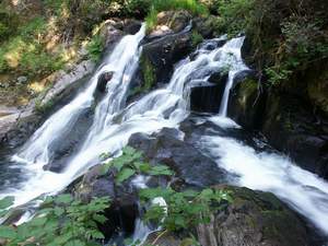
 Sweet Creek Falls
Rating: **
Form: punchbowl
Magnitude: 35
Access: trail (page 244)
USGS Map: Goodwin Peak (1984)
Edition: 4th
Sweet Creek Falls
Rating: **
Form: punchbowl
Magnitude: 35
Access: trail (page 244)
USGS Map: Goodwin Peak (1984)
Edition: 4th
 Beaver Creek Falls
Rating: ***
Form: segmented
Magnitude: 44
Access: trail (page 245)
USGS Map: Goodwin Peak (1984)
Edition: 4th
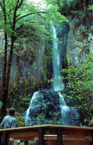
 Upper Kentucky Falls
Rating: ***
Form: segmented
Magnitude: 66
Access: trail (page 245)
USGS Map: Baldy Mtn (1984 ns)
Edition: 2nd
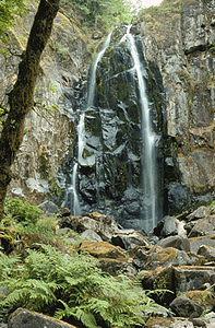
 Lower Kentucky Falls
Rating: ****
Form: tiered
Magnitude: 48
Access: trail (page 245)
USGS Map: Baldy Mtn (1984 ns)
Edition: 2nd
 North Fork Falls
Rating: ***
Form: fan
Magnitude: 26 (l)
Access: trail (page 246)
USGS Map: Baldy Mtn (1984)
Edition: 2nd
More
How is it this guidebook has so many waterfalls not previously mentioned or described in its previous editions? One reason is that they were not shown on topographic or national forest maps, so were not known by the author to exist. Another is in practicality they were not accessible until trails were constructed allowing visitation by the general public.
Such is the case with twelve waterfalls occurring along Sweet Creek. While none of them rank among the best of the Northwest, collectively they should quench the thirst of any waterfall lover. Adding to the delightful journey is an adventurous, yet safe, trail that was constructed within Siuslaw National Forest in order to experience them. As only two of the descents have official names, the rest have been given names that are either synonyms for the word "sweet", such as honey, candy, nectar and sugar; or have similar meanings in other languages, including alaqua and sakari (Native American), dulce (Spanish), anabek (latin), mignonette (French) and marsala (Italian).
Click Here for Honey Falls (u), USGS Goodwin Peak (1984 ns). NEW!
Click Here for Candy Falls (u), USGS Goodwin Peak (1984 ns). NEW!
Click Here for Alaqua Falls (u), USGS Goodwin Peak (1984 ns). NEW!
Click Here for Dulce Falls (u), USGS Goodwin Peak (1984 ns). NEW!
Click Here for Sakari Falls (u), USGS Goodwin Peak (1984 ns). NEW!
Click Here for Anabek Falls (u), USGS Goodwin Peak (1984 ns). NEW!
Click Here for Annice Falls, USGS Goodwin Peak (1984 ns). NEW!
Click Here for Nectar Falls (u), USGS Goodwin Peak (1984 ns). NEW!
Click Here for Sugar Falls (u), USGS Goodwin Peak (1984 ns). NEW!
Click Here for Mignonette Falls (u), USGS Goodwin Peak (1984 ns). NEW!
Click Here for Marsala Falls (u), USGS Goodwin Peak (1984 ns). NEW!
Click Here for Upper Rock Slide, USGS Triangle Lake (1984 ns). NEW!
Click Here for Lower Rock Slide, USGS Triangle Lake (1984 ns). NEW!
Click Here for Lake Creek Falls, USGS Triangle Lake (1984 ns). NEW!
Click Here for The Horn, USGS Mapleton (1984 nl).
Output the CLICK HERE pages to match your hardcopy book by changing your printer settings to 9" x 5 3/4".
COPYRIGHT 2013 by Gregory A. Plumb
GUIDEBOOK published by
Mountaineers Books