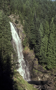
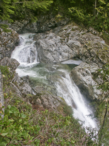
 Lower Wallace Falls
Rating: ***
Form: tiered
Magnitude: 49
Access: trail (page 53)
USGS Map: Gold Bar (1989 nl)
Edition: 5th
 Lower Wallace Falls
Rating: ***
Form: tiered
Magnitude: 49
Access: trail (page 53)
USGS Map: Gold Bar (1989 nl)
Edition: 5th
 Picnic Falls (u)
Rating: **
Form: tiered
Magnitude: 50
Access: trail (page 53)
USGS Map: Gold Bar (1989 nl)
Edition: 5th
 Wallace Falls
Rating: *****
Form: horsetail
Magnitude: 88
Access: trail (page 54)
USGS Map: Gold Bar (1989)
Edition: 1st
 Wallace Top Falls (u)
Rating: **
Form: tiered
Magnitude: 43
Access: trail (page 55)
USGS Map: Wallace Lake (1989 ns)
Edition: 5th
 Upper Wallace Falls
Rating: ***
Form: tiered
Magnitude: 69
Access: trail (page 55)
USGS Map: Wallace Lake (1989 nl)
Edition: 5th
More
Click Here for Small Falls, USGS Gold Bar (1989 ns).
Output the CLICK HERE page to match your hardcopy book by changing your printer settings to 9" x 5 3/4".
Others
Located nearby on private property and inaccessible is Olney Falls,
USGS Wallace Lake (1989). It is likely difficult or not possible
to reach backcountry
Greider Creek Falls (u), USGS Mount Stickney (1989 nl),
Greider Lake Falls (u), USGS Mount Stickney (1989 nl),
Elk Falls (u), USGS Mount Stickney (1989 nl),
Middle Elk Falls (u), USGS Mount Stickney (1989 nl),
Upper Elk Falls (u), USGS Mount Stickney (1989 nl), and
Salmon Branch Falls (u), USGS Mount Stickney (1989 nl).
COPYRIGHT 2013 by Gregory A. Plumb
GUIDEBOOK published by
Mountaineers Books