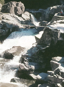
 Granite Falls
Rating: **
Form: rapids
Magnitude: 27
Access: auto (page 57)
USGS Map: Granite Falls (1989)
Edition: 1st
Granite Falls
Rating: **
Form: rapids
Magnitude: 27
Access: auto (page 57)
USGS Map: Granite Falls (1989)
Edition: 1st
More
Click Here for Explorer Falls, USGS Lake Chaplain (1989 ns).
Output the CLICK HERE page to match your hardcopy book by changing your printer settings to 9" x 5 3/4".
Others
Google Earth imagery shows Lower Canyon Creek Falls, USGS Granite Falls (1989 nl), Middle Canyon Creek Falls, USGS Granite Falls (1989 nl), and Upper Canyon Creek Falls (u), USGS Granite Falls (1989 nl), to be in residential neighborhoods and likely on restricted private property. They don't look on the imagery to be much more than rapids, anyway.
A private gated access road prevents visitation to Kelly Creek Falls
(u), USGS Verlot (1989 ns). The same holds true for Marsh
Creek Falls (u), USGS Lake Chaplain (1989 nl), whose topographic map
implies may be quite scenic.
COPYRIGHT 2024 by Gregory A. Plumb
GUIDEBOOK published by
Mountaineers Books