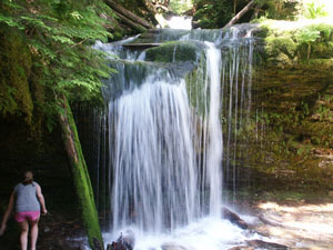
A Waterfall Lover's Guide to the Pacific Northwest 4th ed.
Idaho Panhandle 
11 Elk Creek
Waterfall Entries (refer to hardcopy book for descriptions and directions; page numbers are provided below)

Upper Elk Falls (u)
Rating: **
Form: punchbowl
Magnitude: 31
Access: trail (page 295)
USGS Map: Elk Creek Falls (1969 nl)


Elk Falls
Rating: ****
Form: horsetail
Magnitude: 72
Access: trail (page 295)
USGS Map: Elk Creek Falls (1969)


Middle Elk Falls (u)
Rating: *
Form: punchbowl
Magnitude: 42
Access: trail (page 295)
USGS Map: Elk Creek Falls (1969 ns)


Twin Falls (u) and Small Falls (u)
Rating: **
Form: tiered
Magnitude: 45
Access: trail (page 295)
USGS Map: Elk Creek Falls (1969 ns)


Lower Elk Falls
Rating: ****
Form: plunge
Magnitude: 72
Access: trail and bushwhack (page 296)
USGS Map: Elk Creek Falls (1969 nl)


Bull Run Creek Falls (u)
Rating: ***
Form: cascade
Magnitude: 60
Access: bushwhack (page 297)
USGS Map: Elk Creek Falls (1969)


Lower Bull Run Creek Falls (u)
Rating: **
Form: fan
Magnitude: 45
Access: bushwhack (page 297)
USGS Map: Elk Creek Falls (1969 ns)


Go to first section of next chapter (Wilderness Idaho)
Go to previous section of Idaho Panhandle
Idaho Panhandle Contents
Master Table of Contents
Master Index
Perform a Selective Search
View Chronogical List of Additions
View Chronogical List of Updates
Place a Book Order Online

Copyright 2008 by Gregory A. Plumb
GUIDEBOOK published by Mountaineers Books