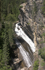
 Granite Falls
Rating: ***
Form: horsetail
Magnitude: 55 (h)
Access: auto or trail (page 339)
USGS Map: Helmer Mtn (1996)
Edition: 1st
Granite Falls
Rating: ***
Form: horsetail
Magnitude: 55 (h)
Access: auto or trail (page 339)
USGS Map: Helmer Mtn (1996)
Edition: 1st
 Upper Granite Falls
Rating: **
Form: punchbowl
Magnitude: 33
Access: trail (page 340)
USGS Map: Helmer Mtn (1996 ns)
Edition: 5th
 Upper Priest Falls
Rating: ****
Form: fan
Magnitude: 71 (h)
Access: high-clearance and trail (page 340)
USGS Map: Continental Mtn (1996)
Photograph by Gary Sheets, Country View Ltd.
Edition: 1st
Others
LaSota Falls,
USGS Helmer Mtn (1996), is located upstream from Upper Granite Falls (listed above) near Roosevelt Grove of Ancient Cedars, but no access could be found when visited in July, 2011. The most recent topographic map shows no roads or trails for
Kalispell Falls, USGS Gleason Mtn (1996), or
Chute Creek Falls (u), Gleason Mtn (1996 nl).
COPYRIGHT 2013 by Gregory A. Plumb
GUIDEBOOK published by
Mountaineers Books