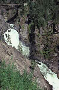
 Moyie Falls
Rating: *****
Form: tiered
Magnitude: 71 (h)
Access: auto (page 346)
USGS Map: Moyie Springs (1996)
Edition: 1st
Update: The town of Moyie Springs is only signed for eastbound traffic along U.S. 2; westbounders will see it signed as Roosevelt St. The road next to the lumberyard is now signed as Canyon View Road. During summer weekdays, the main upper falls is dry due to water diverted for hydroelectric power by the City of Bonners Ferry. The trestle that once spanned above the falls no longer exists.
More
Click Here for Skin Creek Falls (u), USGS Meadow Creek (1996 ns). NEW!
Output the CLICK HERE pages to match your hardcopy book by changing your printer settings to 9" x 5 3/4".