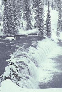
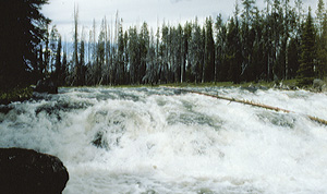
 Sheep Falls
Rating: ***
Form: segmented
Magnitude: 51
Access: trail (page 385)
USGS Map: Sheep Falls (1989)
Edition: 1st
Sheep Falls
Rating: ***
Form: segmented
Magnitude: 51
Access: trail (page 385)
USGS Map: Sheep Falls (1989)
Edition: 1st
 Cave Falls
Rating: ****
Form: block
Magnitude: 73
Access: auto (page 386)
USGS Map: Cave Falls (1989)
Edition: 1st
 Lower Cave Falls (u)
Rating: **
Form: block
Magnitude: 40
Access: auto (page 386)
USGS Map: Cave Falls (1989 nl)
Edition: 3rd
 Bechler Falls
Rating: **
Form: block
Magnitude: 31
Access: trail (page 386)
USGS Map: Bechler Falls (1989)
Edition: 1st
Others
A wealth of waterfalls occur within the Fall River Basin of Yellowstone National Park. Due to the stark nature of this area, it is recommended only for experienced and well-conditioned hikers and backpackers.
Obtain the magnificent guidebook, Yellowstone Waterfalls and Their Discovery, by Paul Rubinstein, Lee H. Whittlesey, and Mike Stevens, for directions and photographs of the following cataracts and more. Only Robinson Canyon Falls occurs in Idaho. All of the other 85 descents within this southwest corner of the park are in Wyoming but are included here due to the area being accessed from the Gem State. Here's a sampling:
Dayhikers:
Cascade Acres, USGS Grassy Lake Reservoir (1989), and
Terraced Falls, USGS Grassy Lake Reservoir (1989).
Ambitious dayhikers and backpackers:
Union Falls, USGS Grassy Lake Reservoir (1989),
Early Morning Falls, USGS Cave Falls (1989 nl),
Ouzel Falls, USGS Cave Falls (1989),
Dunanda Falls, USGS Bechler Falls (1989),
Silver Scarf Falls, USGS Bechler Falls (1989),
Birdseye Falls (u), USGS Bechler Falls (1989 nl),
Confederate Falls (u), USGS Bechler Falls (1989 nl),
Colonnade Falls, USGS Cave Falls (1989),
Iris Falls, USGS Cave Falls (1989), and
Rainbow Falls, USGS Cave Falls (1989).
Backpackers:
Morning Falls (u), USGS Cave Falls (1989 nl),
Robinson Canyon Falls (u), USGS Bechler Falls (1989 nl),
Ragged Falls, USGS Trischman Knob (1986),
Albright Falls, USGS Trischman Knob (1986 nl),
Quiver Cascade, USGS Trischman Knob (1986),
Tendoy Falls, USGS Trischman Knob (1986),
Gwinna Falls, USGS Trischman Knob (1986),
Sluiceway Falls, USGS Trischman Knob (1986),
Wahhi Falls, USGS Trischman Knob (1986),
Horseshoe Cascade (u) USGS Buffalo Lake (1986 ns), and
Deep Pool Falls (u), USGS Buffalo Lake (1986 nl);
Significant bushwhack: White Angel Falls (u), USGS Cave Falls (1989 nl).
COPYRIGHT 2013 by Gregory A. Plumb
GUIDEBOOK published by
Mountaineers Books