NORTH CUMBERLAND
8 Obed River
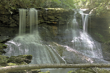
Melton Mill Falls (u)
Rating: * * *
Magnitude: 54
Form: segmented
Access: trail
Distance: 0.2 miles
Difficulty: moderate
Watershed: sm
USGS Map: Lancing (1984 ns)
Page in Guidebook: 145
cross-reference
Update: Development of an overlook has made this entry easier
to access. Parking for the trailhead is on the west side of Lilly
Bridge. Start hiking where the path is signed as Bridge Trail.
You will almost immediately bear left at a fork, taking the lower
route. In about 0.1 mile, you will ascend to the base of some bluffs.
Turn left here and hike another 0.1 mile to the creek and its
cataract, which morphs into a block form during high streamflow.
Go To: Next Entry | Previous Entry
Next Section | Previous Section
Next Chapter | Previous Chapter
Chapter Contents
Master Table of Contents
Index of this Chapter
Master Index
Index by Chapter
Updates
New Entries
Purchase the Guidebook
Copyright 2016 by Gregory A. Plumb