NORTH CUMBERLAND
8 Obed River
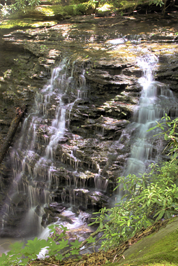
Lower Melton Mill Falls (u)
Rating: * *
Magnitude: 42
Form: segmented
Access: trail & bushwhack
Distance: 0.2 miles
Difficulty: moderate
Watershed: sm
USGS Map: Lancing (1984 ns)
Page in Guidebook: 146
cross-reference
Description: Melton Mill Branch tumbles 25 to 35 feet
along its way to Clear Creek within Obed Wild and
Scenic River.
Directions: Upon your return from the previous entry
(just after you descend from the bluffs), find a thin
path that heads back toward the creek where the trail
takes a sharp bend. Soon the path makes its way to
an excellent rock vista above this descent. Due to the
sheer drop from the vantage, for safety sake don't
bring immature persons to this site.
Go To: Previous Entry
Next Section | Previous Section
Next Chapter | Previous Chapter
Chapter Contents
Master Table of Contents
Index of this Chapter
Master Index
Index by Chapter
Updates
New Entries
Purchase the Guidebook
Copyright 2016 by Gregory A. Plumb