A Waterfall Lover's Guide to the Pacific Northwest 5th ed.
Columbia Gorge
6 Eagle Creek
Waterfall Entries (refer to hardcopy
book for descriptions and directions; page numbers are provided below)
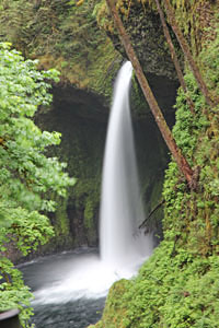 Metlako Falls
Rating: ****
Form: plunge
Magnitude: 73 (h)
Access: trail (page 212)
USGS Map: Bonneville Dam (1994)
Edition: 1st
Update: OregonHikers.org has reported the natural vista for Melako Falls
has fallen into Eagle Creek Gorge. ACCESS TO THIS WATERFALL NO LONGER EXISTS.
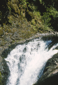
 Lower Punch Bowl Falls
Rating: ***
Form: punchbowl
Magnitude: 19
Access: trail (page 213)
USGS Map: Tanner Butte (1994 ns)
Edition: 1st
 Punch Bowl Falls
Rating: ****
Form: punchbowl
Magnitude: 48 (h)
Access: trail (page 213)
USGS Map: Tanner Butte (1994)
Edition: 3rd
 Loowit Falls
Rating: **
Form: horsetail
Magnitude: 21 (l)
Access: trail (page 213)
USGS Map: Tanner Butte (1994)
Edition: 2nd
 Skoonichuk Falls
Rating: **
Form: tiered
Magnitude: 61
Access: trail (page 213)
USGS Map: Tanner Butte (1994 nl)
Edition: 2nd
 Wy'East Falls (u)
Rating: **
Form: plunge
Magnitude: 30 (l)
Access: trail and bushwhack (page 214)
USGS Map: Wahtum Lake (1994 nl)
Edition: 2nd
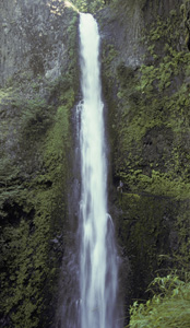 Tunnel Falls
Rating: *****
Form: plunge
Magnitude: 67
Access: trail or backpack (page 214)
USGS Map: Wahtum Lake (1994)
Edition: 2nd
 Twister Falls
Rating: ***
Form: tiered
Magnitude: 37
Access: trail or backpack (page 215)
USGS Map: Wahtum Lake (1994 nl)
Edition: 2nd
Update: previously unoffically called Eagle Creek Falls.
More
Click Here for Ruckel Creek Falls (u), USGS Bonneville Dam (1994 ns).
Click Here for Tenas Falls (u), USGS Tanner Butte (1994 ns).
Click Here for Blue Grouse Falls (u), USGS Wahtum Lake (1994 nl).
Output the CLICK HERE pages to match your hardcopy book by changing your printer settings to 9" x 5 3/4".
Wauna Falls (u), USGS Bonneville Dam (1994 nl), is described on page 212 of the guidebook. It has been difficult to see the last two times the author has visited, therefore it is now relegated to be worthy of nothing more than a mention. Beyond Loowit Falls (described earlier), only the 10- to 20-foot base of Benson Falls (u), USGS Tanner Butte (1994 nl), is visible from Eagle Creek Trail #440 a short distance past High Bridge crossing. Obscured from views year-round is Four Mile Falls (u), USGS Tanner Butte (1994 nl). It is located along an unnamed tributary on the opposite side of Eagle Creek from Trail #440, between Tenas Camp and 4 1/2 Mile Bridge (described earlier).
Others
Each of the following cataracts occur along tributaries
well above Eagle Creek Gorge, thus cannot be seen:
Sorenson Creek Falls (u), USGS Bonneville Dam (1994 nl),
Tish Creek Falls (u), USGS Tanner Butte (1994 nl), Upper Wauna Falls (u), USGS Tanner Butte (1994 nl), Opal Creek Falls (u), Tanner Butte (1994 nl), Upper Opal Creek Falls (u), Tanner Butte (1994 nl),
Upper Tenas Falls (u) USGS Tanner Butte (1994 nl), Middle Four Mile Falls, USGS Wahtum Lake (1994 nl),
Upper Four Mile Falls(u), USGS Wahtum Lake (1994 nl),
North Benson Falls (u), USGS Wahtum Lake (1994 nl),
Waucoma South Falls (u), USGS Wahtum Lake (1994 nl),
Waucoma North Falls (u), USGS Wahtum Lake (1994 nl),
Eagle Tanner Falls (u), USGS Wahtum Lake (1994 nl), and
East Fork Falls (u), USGS Wahtum Lake (1994 nl)
Toward the headwaters of Eagle Creek, access is unlikely to
Falls Creek Falls (u), USGS Tanner Butte (1994 nl),
Upper Falls Creek Falls (u), USGS Tanner Butte (1994 nl),
West Branch Falls (u), USGS Tanner Butte (1994 nl), and
Upper West Branch Falls (u), USGS Tanner Butte (1994 nl).
Also inaccessible are Middle Ruckel Creek Falls (u), USGS Bonneville Dam (1994 nl) and
Upper Ruckel Creek Falls (u), USGS Bonneville Dam (1994 nl).
Go to next section of Columbia Gorge
Go to previous section of Columbia
Gorge
Columbia Gorge Contents
Columbia Gorge Index
Master Table of Contents
Master Index
Perform a Selective Search
View Chronological List of Additions
View Chronological List of Updates
Place
a Book Order Online
COPYRIGHT 2024 by Gregory A. Plumb
GUIDEBOOK published by
Mountaineers Books