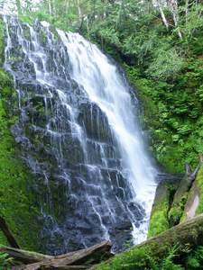
 University Falls
Rating: ***
Form: horsetail
Magnitude: 59
Access: trail (page 234)
USGS Map: Woods Point (1979)
Edition: 4th
University Falls
Rating: ***
Form: horsetail
Magnitude: 59
Access: trail (page 234)
USGS Map: Woods Point (1979)
Edition: 4th
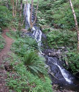
 Fern Rock Falls
Rating: **
Form: fan
Magnitude: 35
Access: auto (page 234)
USGS Map: Woods Point (1979 ns)
Edition: 4th
Update: Previously called Fern Rock Creek Falls.
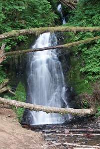
 Bridge Creek Falls
Rating: **
Form: tiered
Magnitude: 25
Access: trail (page 235)
USGS Map: Jordan Creek (1984 ns)
Edition: 4th
More
Click Here for Blumenthal Falls, USGS Arch Cape (1985 ns). NEW!
Click Here for Umbrella Falls, USGS Soapstone Lake (1985 ns). NEW!
Click Here for Little Falls, USGS Elsie (1984).
Click Here for Nehalem Falls, USGS Foley Peak (1985).
Click Here for Wilson Falls, USGS Jordan Creek (1984 ns) NEW!
Click Here for Lower Bridge Creek Falls (u), USGS Jordan Creek (1984 ns) NEW!
Click Here for Lester Creek Falls, USGS Jordan Creek (1984 ns). NEW!
Output the CLICK HERE pages to match your hardcopy book by changing your printer settings to 9" x 5 3/4".
Others
Use the following Waterfalls for Intrepid Explorers hyperlink to access an index for information on exploring the following waterfalls:
Hug Creek Falls (u), USGS Arch Cape (1985 ns)
Necarney Falls, USGS Arch Cape (1985 ns)
Kilchis Falls, USGS Cedar Butte (1984)
East Idiot Falls, USGS Cochran (1974 ns)
Idiot Creek Falls, USGS Cochran (1974 ns)
Upper East Falls, USGS Cochran (1974 ns)
Lower Idiot Creek Falls (u), USGS Cochran (1974 ns)
Middle Stafford Falls, USGS Woods Point (1979 ns)
Stafford Falls, USGS Woods Point (1979 ns)
Upper Stafford Falls, USGS Cochran (1974 ns)
Aerial imagery shows clear cuts adjacent to North Fork Falls, USGS Hamlet (1984 nl), so its accessibility is suspect.
Copyright 2021 by Gregory A. Plumb
GUIDEBOOK published by
Mountaineers Books