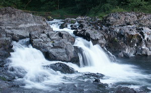
 Lucia Falls
Rating: **
Form: block
Magnitude: 44 (h)
Access: auto (page 170)
USGS Map: Yacolt (1990)
Edition: 1st
Lucia Falls
Rating: **
Form: block
Magnitude: 44 (h)
Access: auto (page 170)
USGS Map: Yacolt (1990)
Edition: 1st
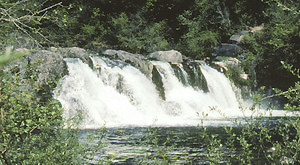
 Yacolt Falls (u)
Rating: **
Form: segmented
Magnitude: 37
Access: trail (page 171)
USGS Map: Yacolt (1990 ns)
Edition: 5th
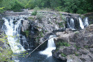
 Sunset Falls
Rating: **
Form: block
Magnitude: 60 (h)
Access: auto (page 171)
USGS Map: Gumboot Mtn (2000 nl)
Edition: 1st
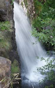 Big Tree Creek Falls (u)
Rating: ***
Form: tiered
Magnitude: 56
Access: trail (page 172)
USGS Map: Dole (2000 nl)
Edition: 4th
More
Click Here for Moulton Falls, USGS Yacolt (1990).
Click Here for Horseshoe Falls, USGS Dole (2000).
Output the CLICK HERE pages to match your hardcopy book by changing your printer settings to 9" x 5 3/4".
Others COPYRIGHT 2013 by Gregory A. Plumb
Use the following Waterfalls for Intrepid Explorers hyperlink to access an index for information on exploring the following waterfall yet to be visited by the author:
Hidden Falls, USGS Dole (2000 nl)
No safe parking place could be found when an attempt was made to find
a path that reportedly leads to Salmon Falls, USGS Yacolt (1990).
Access is uncertain to Upper Big Tree Creek Falls (u), USGS Yale
Dam (2000 ns). Tarbell Trail passes near Rock Creek Falls (u), USGS Larch Mtn (2000 nl), but the terrain and vegetation prevents a view.
Go to next section of Gifford Pinchot
Country
Go to previous section of Gifford Pinchot
Country
Gifford Pinchot Country Contents
Gifford Pinchot Index
Master Table of Contents
Master Index
Perform a Selective Search
View Chronological List of Additions
View Chronological List of Updates
Place
a Book Order Online
GUIDEBOOK published by
Mountaineers Books