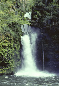
 Curly
Creek Falls
Curly
Creek Falls
Rating: ****
Form: tiered
Magnitude: 66 (h)
Access: trail (page 161)
USGS Map: Burnt Peak (1998)
Edition: 1st
Curly
Creek Falls
Rating: ****
Form: tiered
Magnitude: 66 (h)
Access: trail (page 161)
USGS Map: Burnt Peak (1998)
Edition: 1st
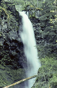 Miller Creek Falls
Rating: **
Form: plunge
Magnitude: 52
Access: trail (page 162)
USGS Map: Burnt Peak (1998 nl)
Edition: 1st
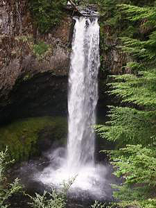 Big
Creek Falls
Big
Creek Falls
Rating: ****
Form: plunge
Magnitude: 76 (h)
Access: trail (page 162)
USGS Map: Burnt Peak (1998)
Edition: 1st
UPDATE: This cataract is not accessible until/unless the Big Creek Falls Trail is repaired.
Hemlock Creek Falls
Rating: **
Form: plunge
Magnitude: 32 (l)
Access: trail (page 163)
USGS Map: Burnt Peak (1998 nl)
Edition: 4th
UPDATE: This cataract is not accessible until/unless the Big Creek Falls Trail is repaired.
More
Click Here for Cave Falls, USGS Burnt Peak (1998 nl). UPDATE: This cataract is not accessible until/unless the Big Creek Falls Trail is repaired.
Click Here for Upper Curly Creek Falls (u), USGS Burnt Peak (1998 ns).
Click Here for Rush Creek Falls, USGS Burnt Peak (1998 ns).
Output the CLICK HERE pages to match your hardcopy book by changing your printer settings to 9" x 5 3/4".
Others COPYRIGHT 2013 by Gregory A. Plumb
Use the following Waterfalls for Intrepid Explorers hyperlink to access an index for information on exploring the following waterfall yet to be visited by the author:
McClellan Falls (u), USGS Burnt Peak (1998 ns)
Go to next section of Gifford Pinchot
Country
Go to previous section of Gifford Pinchot
Country
Gifford Pinchot Country Contents
Gifford Pinchot Index
Master Table of Contents
Master Index
Perform a Selective Search
View Chronological List of Additions
View Chronological List of Updates
Place a Book Order Online
GUIDEBOOK published by
Mountaineers Books