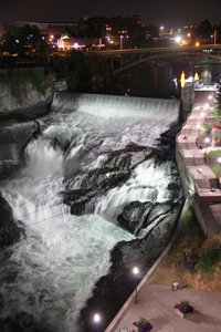
 Spokane Falls
Rating: ****
Form: cascade
Magnitude: 82 (h)
Access: auto (page 181)
USGS Map: Spokane NW (1986)
Edition: 1st
Spokane Falls
Rating: ****
Form: cascade
Magnitude: 82 (h)
Access: auto (page 181)
USGS Map: Spokane NW (1986)
Edition: 1st
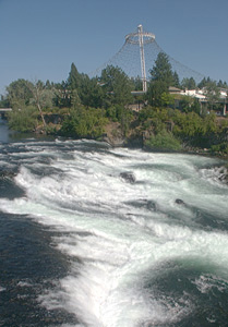
 Upper Falls
Rating: ***
Form: segmented
Magnitude: 60 (h)
Access: auto (page 182)
USGS Map: Spokane NW (1986 nl)
Edition: 1st
 Canada Island Falls (u)
Rating: **
Form: rapids
Magnitude: 49 (h)
Access: trail (page 182)
USGS Map: Spokane NW (1986 ns)
Edition: 3rd
More
Click Here for Diversion Dam Falls (u), USGS Spokane NW (1986 ns).
Output the CLICK HERE page to match your hardcopy book by changing your printer settings to 9" x 5 3/4".
Others
Nine Mile Falls, USGS Nine Mile Falls (1986 ns) no longer exists due to the dam and reservoir system along this reach of the Spokane River.
The same can be said for Hn(wa'(we'elshn Falls, USGS Spokane NE (1986 ns), which in native tongue means "place for vomiting".
Go to next section of
Inland Empire
Go to last section of previous chapter (Gifford Pinchot)
Inland Empire Contents
Inland Empire Index
Master Table of Contents
Master Index
Perform a Selective Search
View Chronological List of Additions
View Chronological List of Updates
Place
a Book Order Online
COPYRIGHT 2024 by Gregory A. Plumb
GUIDEBOOK published by
Mountaineers Books