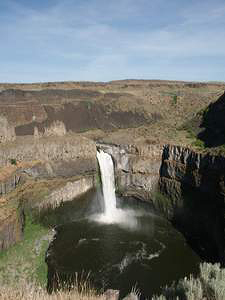
 Palouse Falls
Rating: *****
Form: plunge
Magnitude: 86
Access: auto (page 198)
USGS Map: Palouse Falls (2011)
Edition: 1st
Palouse Falls
Rating: *****
Form: plunge
Magnitude: 86
Access: auto (page 198)
USGS Map: Palouse Falls (2011)
Edition: 1st
More
Click Here for Middle Palouse Falls (u), USGS Palouse Falls (2011 ns). NEW!
Click Here for Little Palouse Falls, USGS Palouse Falls (2011).
Click Here for Gildersleeve Falls, formerly Upper Palouse Falls (u), USGS Palouse Falls (2011 nl).
Output the CLICK HERE pages to match your hardcopy book by changing your printer settings to 9" x 5 3/4".
Others
Cow Creek Falls (u), USGS Coyote Butte (1981 nl) is a small waterfall on private property with no trespassing. The owners allowed the author to take this photograph for documentary purposes.
Upper Cow Creek Falls (u), USGS Coyote Butte (1981 nl), does not appear accessible. Thick brush masks any view of small
Weimer Creek Falls(u), USGS Falling Springs (1981 nl). Nothing larger than a riffle could be found at
Tucannon River Falls (u), USGS Tucannon (1967 nl).
Not much is to be seen at Hompegg Falls, USGS Eckler Mtn (1995), which was obliterated by a flood in 1931.
Sheep Creek Falls (u), USGS Stentz Spring (1995 nl), is not likely accessible.
COPYRIGHT 2013 by Gregory A. Plumb
GUIDEBOOK published by
Mountaineers Books
)