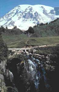
 Ruby Falls
Rating: **
Form: block
Magnitude: 48 (h)
Access: auto (page 125)
USGS Map: Mt. Rainier East (1971 ns)
Edition: 4th
 Washington Cascades
Rating: ***
Form: tiered
Magnitude: 33
Access: trail (page 126)
USGS Map: Mt. Rainier East (1971 ns)
Edition: 5th
More COPYRIGHT 2013 by Gregory A. Plumb
 Myrtle Falls
Rating: ***
Form: fan
Magnitude: 34 (l)
Access: trail (page 127)
USGS Map: Mt. Rainier East (1971 ns)
Edition: 1st
 Sluiskin
Falls
Rating: ***
Form: fan
Magnitude: 40 (l)
Access: trail with optional bushwhack (page 127)
USGS Map: Mt. Rainier East (1971)
Edition: 1st
Update: The old saucer-shaped visitor center no longer exists.
Click Here for Upper Ruby Falls (u), USGS Mt. Rainier East (1971 ns).
Click Here for Paradise Valley Falls (u), USGS Mt. Rainier East (1971 ns).
Click Here for Paradise Falls (u), USGS Mt. Rainier East (1971 nl).
Click Here for Edith Gorge Falls, USGS Mt. Rainier East (1971 ns).
Click Here for Wilson Falls (u), USGS Mt. Rainier West (1971 nl).
Click Here for Nisqually Moraine Falls (u), USGS Mt. Rainier West (1971 ns).
Output the CLICK HERE pages to match your hardcopy book by changing your printer settings to 9" x 5 3/4".
Go to next section of Mount Rainier
Go to previous section of Mount Rainier
Mount Rainier Contents
Mount Rainier Index
Master Table of Contents
Master Index
Perform a Selective Search
View Chronological List of Additions
View Chronological List of Updates
Place
a Book Order Online
GUIDEBOOK published by
Mountaineers Books