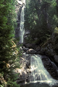
 Rainbow Falls
Rating: *****
Form: tiered
Magnitude: 92
Access: tour boat and shuttle bus (page 84)
USGS Map: Stehekin (1987)
Edition: 1st
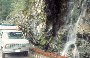
 Carwash Falls
Rating: **
Form: horsetail
Magnitude: 24 (l)
Access: tour boat and shuttle bus (page 84)
USGS Map: McGregor Mtn (1987 ns)
Edition: 1st
 Domke Falls
Rating: **
Form: fan
Magnitude: 33
Access: tour boat (page 84)
USGS Map: Lucerne (1988)
Edition: 1st
More
Click Here for Bridal Veil Falls, USGS Stehekin (1987).
Output the CLICK HERE page to match your hardcopy book by changing your printer settings to 9" x 5 3/4".
Others COPYRIGHT 2013 by Gregory A. Plumb
Near the Holden Village area, the forest service in concert with area residents have constructed trails to several waterfalls not yet visited by the author. Click over the cataract desired for details.
Copper Falls, USGS Holden (1988 nl)
Monkey Bear Falls, USGS Pinnacle Mountain (1988 ns)
Ten Mile Falls, USGS Holden (1988 nl)
Use the following Waterfalls for Intrepid Explorers hyperlink to access an index for information on seeking out these additional waterfalls:
Agnes Gorge Falls (u), USGS Mount Lyall (1987 ns)
Crown Point Falls, USGS Suiattle Pass (1988)
Hart Lake Falls (u), USGS Holden (1988 nl)
Lyman Lake Falls (u), USGS Suiattle Pass (1988 nl)
It is unlikely you will see a distant view along the shuttle bus route of Stehekin Falls (u), USGS McGregor Mtn (1987 nl), as it is usually dry during the summer.
Go to next section of North Cascades
Go to previous section of North Cascades
North Cascades Contents
North Cascades Index
Master Table of Contents
Master Index
Perform a Selective Search
View Chronological List of Additions
View Chronological List of Updates
Place
a Book Order Online
GUIDEBOOK published by
Mountaineers Books