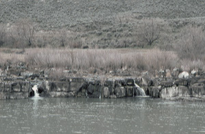
 Lower Salmon Falls
Rating: **
Form: block
Magnitude: 50
Access: auto (page 375)
USGS Map: Hagerman (1992)
Edition: 1st
Lower Salmon Falls
Rating: **
Form: block
Magnitude: 50
Access: auto (page 375)
USGS Map: Hagerman (1992)
Edition: 1st
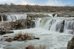 Salmon Falls
Rating: ***
Form: segmented
Magnitude: 70
Access: hike (page 376)
USGS Map: Hagerman (1992)
Edition: 1st
Update: Also known as Upper Salmon Falls
More
Click Here for Devils Wash Bowl, USGS Tuttle (1992). NEW!
Click Here for Indian Bathtub Falls (u), USGS Hot Springs (1992 nl).
Click Here for Deadman Falls, USGS Glenns Ferry (1992).
Click Here for Clover Creek Falls, (u), USGS King Hill (1986 nl).
Output the CLICK HERE pages to match your hardcopy book by changing your printer settings to 9" x 5 3/4".
Others
Use the following Waterfalls for Intrepid Explorers hyperlink to access an index for information on exploring the following waterfalls:
Zeno Falls, USGS Hill Pasture (1972 ns)
Camel Falls, USGS Wagon Box Basin (1973)
Austin Butte Falls (u), USGS Austin Butte (1980 nl)
Topographic maps imply the following waterfalls are not accessible: The Falls, USGS Sugarloaf (1972); and Sheepshead Draw Falls (u), USGS Winter Camp (1980 nl).
COPYRIGHT 2013 by Gregory A. Plumb
GUIDEBOOK published by
Mountaineers Books