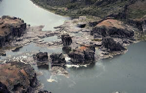
 Piller Falls
Rating: ***
Form: rapids
Magnitude: 53
Access: hike or bushwhack (page 377)
USGS Map: Twin Falls (1992)
Updated Navigation Map: Click Here
)
Edition: 1st
Update: Developed vistas now exist from two paved Canyon Rim Trail locations.
One is 0.2 miles upriver from the east parking lot of the Canyon View shopping center.
The other is near the Evel Knievel Jump Site 1.2 miles downriver from Shoshone Falls Park.
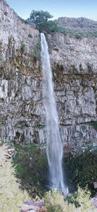 Perrine Coulee Falls
Rating: ****
Form: plunge
Magnitude: 90 (h)
Access: auto (page 378)
USGS Map: Twin Falls (1992)
Edition: 1st
 Twin Falls
Rating: ****
Form: segmented (originally)
Magnitude: 96 (h)
Access: auto (page 378)
USGS Map: Kimberly (1992)
Edition: 1st
Update: An improved viewing platform has been constructed for admiring the falls.
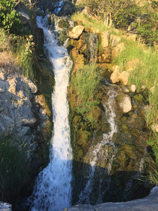 Bridal Veil Falls
Rating: **
Form: horsetail
Magnitude: 30
Access: auto (page 379)
USGS Map: Twin Falls (1992 ns)
Edition: 1st
Update: If you wish more than a car window view, use the developed parking area just around the bend.
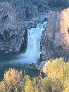
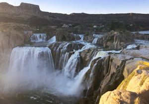 Shoshone Falls
Rating: *****
Form: block
Magnitude: 120
Access: auto (page 380)
USGS Map: Twin Falls (1992)
Edition: 1st
Update: The City of Twin Falls has made big improvements to Shoshone Falls Park.
The viewing platform has been reconstructed and additional vistas exist down the paved Canyon Rim Trail.
There is now a nominal entrance fee to visit the park.
More
Click Here for Grandview Falls (u), USGS Twin Falls (1992 ns). NEW!
Click Here for Irrigation Falls (u), USGS Filer (1992 ns). NEW!
Click Here for On or Off Falls (u), USGS Filer (1992 ns). NEW!
Click Here for Auger Falls, USGS Jerome (1992). REVISED!
Click Here for Upper Jerome Falls (u), USGS Jerome (1992 ns). NEW!
Click Here for Jerome Falls (u), USGS Jerome (1992 ns). NEW!
Click Here for Mary Alice Falls, USGS Twin Falls (1992 ns). NEW!
Click Here for Big Drops, USGS Shoshone (1992).
Click Here for Little Drops, USGS Shoshone (1992). NEW!
Click Here for Caldron Linn, USGS Murtaugh (1992). NEW!
Click Here for Ross Falls, USGS Pike Mtn (2017). NEW!
Output the CLICK HERE pages to match your hardcopy book by changing your printer settings to 9" x 5 3/4".
Others COPYRIGHT 2024 by Gregory A. Plumb
Use the following Waterfalls for Intrepid Explorers hyperlink to access an index for information on exploring the following waterfall:
Phantom Falls, USGS Mahogany Butte (1977 nl)
Go to next section of Snake River Plain
Go to previous section of Snake River
Plain
Snake River Plain Contents
Snake River Plain Index
Master Table of Contents
Master Index
Perform a Selective Search
View Chronological List of Additions
View Chronological List of Updates
Place
a Book Order Online
GUIDEBOOK published by
Mountaineers Books