 Sherars Falls
Rating: ***
Form: block
Magnitude: 46 (h)
Access: auto (page 318)
USGS Map: Sherars Bridge (1987 ns)
Edition: 3rd
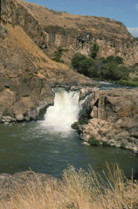
 Sherars Falls
Rating: ***
Form: block
Magnitude: 46 (h)
Access: auto (page 318)
USGS Map: Sherars Bridge (1987 ns)
Edition: 3rd
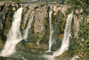
 White River Falls
Rating: ***
Form: segmented
Magnitude: 72
Access: auto (page 319)
USGS Map: Maupin (1996 ns)
Edition: 3rd
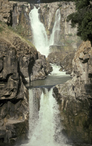
 Celestial Falls
Rating: ****
Form: tiered
Magnitude: 75
Access: trail (page 319)
USGS Map: Maupin (1996 ns)
Edition: 3rd
Update: The lower tier shown in the accompanying photograph was formerly unoffically called
Middle White River Falls . The upper tier is a part of White River Falls
 Lower White River Falls (u)
Rating: **
Form: punchbowl
Magnitude: 50
Access: trail (page 319)
USGS Map: Maupin (1996 ns)
Edition: 3rd
More
Click Here for Wolf Hollow Falls, USGS Wolf Hollow Falls (1970 nl). NEW!
Click Here for Waterfalls Hollow Falls (u), USGS Wolf Hollow Falls (1970 nl). NEW!
Output the CLICK HERE pages to match your hardcopy book by changing your printer settings to 9" x 5 3/4".
Others
Use the following Waterfalls for Intrepid Explorers hyperlink to access an index for information on exploring the following waterfalls yet to be visited by the author:
Tumwater Falls, USGS Quinton (1971 ns)
Meadow Brooks Falls, USGS Dale (1995)
Buck Falls, USGS Chapin Creek (1995), is on private property with no trespassing. Maps show lack of access to the following cataracts along their seasonal drainageways:
Horseshoe Falls, USGS Harmony (1971),
Thompson Falls, USGS Thompson Flat (1995),
Glutton Falls, USGS Hardman (1969),
Chapman Hollow Falls (u), Macken Canyon (1970 nl), and
Pine Hollow Falls (u), USGS Macken Canyon (1970 nl).
Go to next section of Columbia Plateau
Go to last section of previous chapter (South Cascades)
Columbia Plateau Contents
Columbia Plateau Index
Master Table of Contents
Master Index
Perform a Selective Search
View Chronological List of Additions
View Chronological List of Updates
Place
a Book Order Online
COPYRIGHT 2013 by Gregory A. Plumb
GUIDEBOOK published by
Mountaineers Books