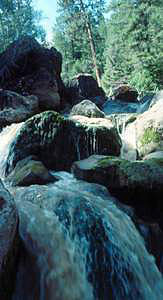
 South Fork Falls
Rating: **
Form: cascade
Magnitude: 28
Access: auto (page 332)
USGS Map: Suplee Butte (1992)
Edition: 4th
South Fork Falls
Rating: **
Form: cascade
Magnitude: 28
Access: auto (page 332)
USGS Map: Suplee Butte (1992)
Edition: 4th
Others
Use the following Waterfalls for Intrepid Explorers hyperlink to access an index for information on exploring the following waterfalls yet to be visited by the author:
Strawberry Falls, USGS Strawberry Mtn (1996)
Slide Falls, USGS Strawberry Mtn (1996 nl)
Emigrant Creek Falls (u), USGS Bear Canyon Butte (1992 ns)
Upper Falls, USGS Keys Creek (1992)
Maps suggest unlikely access to Lower Falls, USGS Committee Creek (1992), North Fork Wolf Falls (u), USGS Tucker Flat (1984 nl),
Fall Creek Falls (u), USGS Mount Vernon (1983 nl),
Chloride Falls (u), USGS Bourne (1984 nl),
North Fork Falls (u), USGS Bourne (1984 nl),
Rock Creek Falls (u), USGS Bourne (1984 nl), and
Upper Rock Creek Falls (u), USGS Bourne (1984 nl).
COPYRIGHT 2013 by Gregory A. Plumb
GUIDEBOOK published by
Mountaineers Books