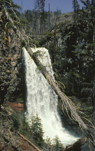
 Tumalo Falls
Rating: ***
Form: plunge
Magnitude: 81
Access: auto (page 322)
USGS Map: Tumalo Falls (1988)
Edition: 1st
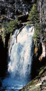
Tumalo Falls
Rating: ***
Form: plunge
Magnitude: 81
Access: auto (page 322)
USGS Map: Tumalo Falls (1988)
Edition: 1st
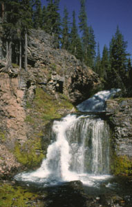 Middle Tumalo Falls (u)
Rating: **
Form: tiered
Magnitude: 52
Access: trail and bushwhack (page 322)
USGS Map: Tumalo Falls (1988 nl)
Edition: 3rd
 Bridge Creek Falls (u)
Rating: **
Form: horsetail
Magnitude: 46
Access: trail (page 323)
USGS Map: Tumalo Falls (1988 nl)
Edition: 3rd
More
Click Here for Cline Falls, USGS Cline Falls (1962).
Click Here for Canal Falls (u), USGS Bend (1981 nl).
Click Here for Steelhead Falls, USGS Steelhead Falls (1992). NEW!
Output the CLICK HERE pages to match your hardcopy book by changing your printer settings to 9" x 5 3/4".
Others The following descents along the Deschutes River are reportedly accessible
only to river-runners: Awbrey Falls, USGS Tumalo (1962);
Big Falls USGS Cline Falls (1962); and
Odin Falls, USGS Cline Falls (1962).
COPYRIGHT 2013 by Gregory A. Plumb
Use the following Waterfalls for Intrepid Explorers hyperlink to access an index for information on exploring the following waterfall yet to be visited by the author:
Upper Tumalo Falls (u), USGS Tumalo Falls (1988 nl)
Go to next section of Columbia Plateau
Go to previous section of Columbia
Plateau
Columbia Plateau Contents
Columbia Plateau Index
Master Table of Contents
Master Index
Perform a Selective Search
View Chronological List of Additions
View Chronological List of Updates
Place
a Book Order Online
GUIDEBOOK published by
Mountaineers Books