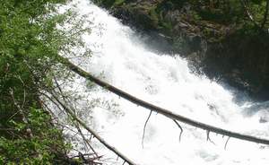
 Hunter Falls
Rating: ***
Form: tiered
Magnitude: 56 (h)
Access: trail (page 329)
USGS Map: North Minam Meadows (1990)
Edition: 4th
Hunter Falls
Rating: ***
Form: tiered
Magnitude: 56 (h)
Access: trail (page 329)
USGS Map: North Minam Meadows (1990)
Edition: 4th
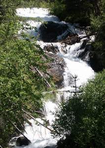 Upper Hunter Falls (u)
Rating: **
Form: cascade
Magnitude: 28 (h)
Access: trail (page 330)
USGS Map: North Minam Meadows (1990 ns)
Edition: 4th
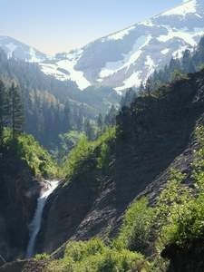 Falls Creek Falls
Rating: ***
Form: horsetail
Magnitude: 53 (h)
Access: trail (page 331)
USGS Map: Chief Joseph Mtn (1990 nl)
Edition: 4th
More
Click Here for Lookingglass Falls, USGS Rondowa (1995).
Output the CLICK HERE page to match your hardcopy book by changing your printer settings to 9" x 5 3/4".
Others
Maps suggest unlikely access to Lower Falls Little Minam River, USGS Mount Fanny (1993 ns), Deep Creek Falls (u), USGS Fingerboard Saddle (1990 nl), and
Silver Creek Falls (u), USGS Chief Joseph Mtn (1990 nl).
COPYRIGHT 2013 by Gregory A. Plumb
Use the following Waterfalls for Intrepid Explorers hyperlink to access an index for information on exploring the following waterfalls yet to be visited by the author:
Minam Falls, USGS Jim White Ridge (1993 ns)
John Henry Falls (u), USGS North Minam Meadows (1990 nl)
Lillyville Falls (u), USGS North Minam Meadows (1990 nl)
Murray Creek Falls (u), USGS Chief Joseph Mtn (1990 nl)
Squaw Falls, USGS Elbow Creek (1995)
Go to next section of Columbia Plateau
Go to previous section of Columbia
Plateau
Columbia Plateau Contents
Columbia Plateau Index
Master Table of Contents
Master Index
Perform a Selective Search
View Chronological List of Additions
View Chronological List of Updates
Place
a Book Order Online
GUIDEBOOK published by
Mountaineers Books