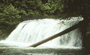
 Middle Falls
Rating: **
Form: block
Magnitude: 62 (h)
Access: trail (page 263)
USGS Map: Estacada (1985 nl)
Edition: 1st
Middle Falls
Rating: **
Form: block
Magnitude: 62 (h)
Access: trail (page 263)
USGS Map: Estacada (1985 nl)
Edition: 1st
More
Click Here for The Falls, USGS Estacada (1985).
Output the CLICK HERE page to match your hardcopy book by changing your printer settings to 9" x 5 3/4".
Others COPYRIGHT 2013 by Gregory A. Plumb
Use the following Waterfalls for Intrepid Explorers hyperlink to access an index for information on exploring the following waterfalls:
Chak Chak Falls (u), USGS Wildcat Mountain (1999 ns)
Tipsu Falls (u), USGS Wildcat Mountain (1999 ns)
When last visited in 2008, Upper Eagle Creek Falls, USGS Cherryville (1997 ns) was on Fish Hatchery property and not open to the general public. There was not much to see anyway as most of the water was being diverted from the falls for the operation of the hatchery.
Maps suggest no apparent access to Memaloose Creek Falls (u), USGS Cascadia (1994 nl),
Upper Memaloose Creek Falls (u), USGS Cascadia (1994 nl), or
South Fork Clackamas Falls (u), USGS Cascadia (1994 nl),
Go to next section of
Middle Cascades
Go to previous section of Middle Cascades
Middle Cascades Contents
Middle Cascades Index
Master Table of Contents
Master Index
Perform a Selective Search
View Chronological List of Additions
View Chronological List of Updates
Place
a Book Order Online
GUIDEBOOK published by
Mountaineers Books