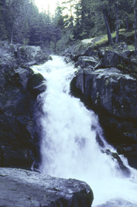
 Silver Falls
Rating: ***
Form: punchbowl
Magnitude: 55 (h)
Access: trail (page 130)
USGS Map: Chinook Pass (1987)
Edition: 1st
 Silver Falls
Rating: ***
Form: punchbowl
Magnitude: 55 (h)
Access: trail (page 130)
USGS Map: Chinook Pass (1987)
Edition: 1st
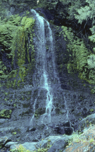
 Fall Creek Falls (u)
Rating: **
Form: horsetail
Magnitude: 24 (l)
Access: auto (page 131)
USGS Map: Chinook Pass (1987 ns)
Edition: 1st
More
Click Here for Olallie Creek Falls (u), USGS Chinook Pass (1987 nl).
Output the CLICK HERE page to match your hardcopy book by changing your printer settings to 9" x 5 3/4".
Others Wauhaukaupauken Falls, USGS Mt. Rainier East (1971)
Several waterfalls drop into Ohanapecosh Park. Climb steadily up switchbacks on the Wonderland Trail from Wanhaukaupauken Falls (listed above). You should see a series of falls streaming from the adjacent
cliffs, coming into view with the parkland to the northeast about one mile past timberline. Huckleberry Creek Falls (u), USGS Mt. Rainier East (1971 nl) Accessibility is very unlikely to the following cataracts: Laughingwater Creek Falls (u), USGS Chinook Pass (1987 nl), Upper Ohanapechosh Falls (u), USGS Mt. Rainier East (1971 nl), Affi Falls, USGS Sunrise (1971), Basaltic Falls, USGS Mt. Rainier East (1971),
Trixie Falls, USGS Mt. Rainier East (1971),
Margaret Falls, USGS Mt. Rainier East (1971),
Twin Falls, USGS Mt. Rainier East (1971),
East Basaltic Falls (u), USGS Mt. Rainier East (1971 nl),
Middle Ohanapechosh Falls (u), USGS Mt. Rainier East (1971 nl),
East Boulder Falls (u), USGS Mt. Rainier East (1971 nl),
Sunrise Falls (u), USGS White River Park (1971 nl),
Mile 13 Falls (u), USGS Chinook Pass (1987 nl),
Saint Johns Falls, USGS Chinook Pass (1987),
Fryingpan Creek Falls (u), USGS Chinook Pass (1987 nl),
Chimneys Falls (u), USGS Chinook Pass (1987 nl),
Upper Chimneys Falls (u), USGS Chinook Pass (1987 nl),
Middle Boulder Creek Falls (u), USGS Chinook Pass (1987 nl),
Upper Boulder Creek Falls (u), USGS Chinook Pass (1987 nl),
Boulder Creek Falls (u), USGS Chinook Pass (1987 nl),
West Ohanapecosh Falls (u), USGS Chinook Pass (1987 nl),
South Ohanapecosh Falls (u), USGS Chinook Pass (1987 nl),
Upper Olallie Falls (u), USGS Chinook Pass (1987 nl),
Needle Creek Falls (u), USGS Chinook Pass (1987 nl),
Goat Mountain Falls (u), USGS Sunrise (1971 nl),
Vernal Park Falls (u), USGS Sunrise (1971 nl),
Upper Van Horn Falls (u), USGS Sunrise (1971 nl), and
Baker Point Falls (u), USGS Sunrise (1971nl).
COPYRIGHT 2013 by Gregory A. Plumb
The extensive trail system within Mount Rainier National Park provides entry to many of the mountain's remote areas. The following backcountry falls are likely accessible, as suggested by their proximity to pack trails.
They are mostly available to only backpackers and the most ambitious day-hikers. Before embarking upon one of these journeys, remember to secure a backpacking permit at a park ranger station.
Use the following Waterfalls for Intrepid Explorers hyperlink to access an index for information on exploring the following waterfalls yet to be visited by the author:
The following five waterfalls are within the basin of Nickel Creek. Hike north from Box Canyon along the Wonderland Trail for 5.5 to 6 miles. Bird's-eye views of the falls should be to the west (left), well
past the heavily timbered region along the Cowlitz Divide ridge.
Marie Falls, USGS Mt. Rainier East (1971)
Mary Belle Falls, USGS Mt. Rainier East (1971)
Lower Nickel Creek Falls (u), USGS Mt. Rainier East (1971 nl)
East Nickel Creek Falls (u), USGS Mt. Rainier East (1971 nl)
West Nickel Creek Falls (u), USGS Mt. Rainier East (1971 nl)
Ohanapecosh Park Falls (u), USGS Mt. Rainier East (1971 nl)
Boulder Junction Falls (u), USGS Mt. Rainier East (1971 nl)
Garda Falls, USGS Sunrise (1971)
Van Horn Falls, USGS Sunrise (1971)
Upper Van Horn Falls, USGS Sunrise (1971 nl)
Go to next section of Mount Rainier
Go to previous section of Mount Rainier
Mount Rainier Contents
Mount Rainier Index
Master Table of Contents
Master Index
Perform a Selective Search
View Chronological List of Additions
View Chronological List of Updates
Place
a Book Order Online
GUIDEBOOK published by
Mountaineers Books