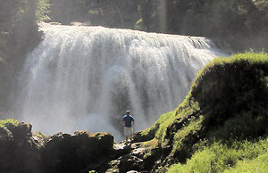
 South
Fork Falls
South
Fork Falls
Rating: ***
Form: block
Magnitude: 66
Access: trail (page 138)
USGS Map: Pinegrass Ridge (2000 nl)
Edition: 1st
South
Fork Falls
Rating: ***
Form: block
Magnitude: 66
Access: trail (page 138)
USGS Map: Pinegrass Ridge (2000 nl)
Edition: 1st
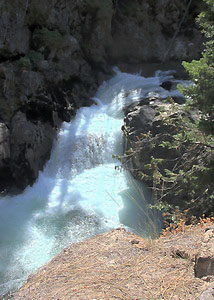 Conrad Meadows Falls (u)
Rating: **
Form: punchbowl
Magnitude: 32
Access: trail (page 139)
USGS Map: Pinegrass Ridge (2000 ns)
Edition: 5th
![]() Clear
Lake Falls
Clear
Lake Falls
Rating: **
Form: tiered
Magnitude: 33
Access: auto (page 139)
USGS Map: Spiral Butte (1988 ns)
Edition: 1st
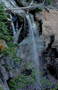 Indian Creek Falls
Rating: **
Form: plunge
Magnitude: 33 (l)
Access: trail & bushwhack (page 139)
USGS Map: Spiral Butte (1988 nl)
Edition: 5th
Others COPYRIGHT 2013 by Gregory A. Plumb
![]() Upper
Clear Creek Falls (u)
Upper
Clear Creek Falls (u)
Rating: ****
Form: fan
Magnitude: 74
Access: auto (page 140)
USGS Map: Spiral Butte (1988 nl)
Edition: 1st
![]() Clear
Creek Falls
Clear
Creek Falls
Rating: *****
Form: plunge
Magnitude: 99
Access: auto (page 140)
USGS Map: Spiral Butte (1988)
Edition: 1st
![]() Clear Creek Fork Falls (u)
Clear Creek Fork Falls (u)
Rating: ****
Form: plunge
Magnitude: 57
Access: bushwhack (page 140)
USGS Map: Spiral Butte (1988 nl)
Edition: 5th
Use the following Waterfalls for Intrepid Explorers hyperlink to access an index for information on exploring the following waterfall yet to be visited by the author:
Feeder Falls (u), USGS Jennies Butte (2000 ns)
Huckleberry Creek Falls (u), USGS Walupt Lake (1970 nl), Lake Corral Falls (u), USGS Walupt Lake (1970 nl), and McCall Basin Falls (u), USGS Old Snowy Mtn (1988 nl) are not likely accessible.
Go to next section of Mount Rainier
Go to previous section of Mount Rainier
Mount Rainier Contents
Mount Rainier Index
Master Table of Contents
Master Index
Perform a Selective Search
View Chronological List of Additions
View Chronological List of Updates
Place
a Book Order Online
GUIDEBOOK published by
Mountaineers Books