A Waterfall Lover's Guide to the Pacific Northwest 5th ed.
Wilderness Idaho
12 Ketchum
Waterfall Entries (refer to hardcopy
book for descriptions and directions; page numbers are provided below)
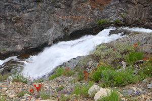
 North Fork Falls (u)
Rating: **
Form: rapids
Magnitude: 32
Access: high clearance and trail (page 370)
USGS Map: Ryan Peak (1967 ns)
Edition: 1st
Update: At the end of North Fork Road, self-register for entering the Hemingway-Boulders Wilderness Area.
There are two trailheads. Take North Fork Trail #115 which is to your right, ascending a hill. Hike 2.0 miles and
bear left at the sign, heading along Upper North Fork Trail #128. A small stream will be forded in 0.9 miles. Soon
you should see ahead of you a rocky feature the river has cut into. It's 0.3 miles to the hill on its immediate right
with a view of the descent a few steps off of the trail. Be very careful near the edge.
More
Click Here for Boulder Mountain Falls (u), USGS Ryan Peak (1967 ns). NEW!
Click Here for Big Fall Creek Falls (u), USGS Phi Kappa Mountain (1967 ns) . NEW!
Click Here for Fall Creek Falls, USGS Standhope Peak (1967 ns). NEW!
Others
Use the following Waterfalls for Intrepid Explorers hyperlink to access an index for information on exploring the following waterfall:
East Pass Creek Falls (u), USGS Meridian Peak (1967 nl)
Only a brief distant glimpse of the top of Trail Creek Falls, USGS Rock
Roll Canyon (1967 nl) is available to passengers driving up Trail Creek Road, due to the lack of safe turnouts along this section of the road. You may also see water streaming distantly across the valley from Basin Gulch.
No trail access is shown on the topographic maps for Boulder Falls (u), USGS Galena Peak (1970
nl).
Go to next section of Wilderness Idaho
Go to previous section of Wilderness
Idaho
Wilderness Idaho Contents
Wilderness Idaho Index
Master Table of Contents
Master Index
Perform a Selective Search
View Chronological List of Additions
View Chronological List of Updates
Place
a Book Order Online
COPYRIGHT 2024 by Gregory A. Plumb
GUIDEBOOK published by
Mountaineers Books
 North Fork Falls (u)