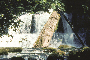
 Lower Falls
Rating: **
Form: tiered
Magnitude: 45
Access: auto (page 279)
USGS Map: Sweet Home (1984 nl)
Edition: 1st
Lower Falls
Rating: **
Form: tiered
Magnitude: 45
Access: auto (page 279)
USGS Map: Sweet Home (1984 nl)
Edition: 1st
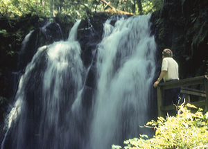
 Royal Terrace Falls
Rating: ***
Form: tiered
Magnitude: 39 (l)
Access: trail (page 279)
USGS Map: Sweet Home (1984 ns)
Edition: 1st
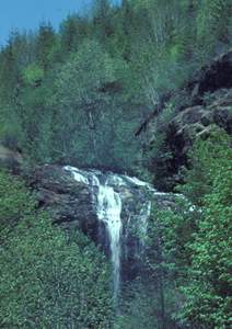
 Majestic Falls
Rating: ***
Form: block
Magnitude: 58
Access: auto (page 279)
USGS Map: Sweet Home (1984 nl)
Edition: 1st
 Coal Creek Falls (u)
Rating: **
Form: plunge
Magnitude: 32 (l)
Access: bushwhack (page 280)
USGS Map: Green Peter (1984 nl)
Edition: 1st
More
Click Here for Crystal Falls, USGS Sweet Home (1984 nl).
Output the CLICK HERE page to match your hardcopy book by changing your printer settings to 9" x 5 3/4".
Others
Use the following Waterfalls for Intrepid Explorers hyperlink to access an index for information on exploring the following waterfalls yet to be visited by the author:
Cascade Falls, USGS Yellowstone Mtn (1985)
West Fork Valley Falls (u), USGS Yellowstone Mtn (1985 nl)
Cascade Falls, USGS Farmers Butte (1997)
Sixes Creek Falls, USGS Quartzville (1994 nl)
Boundary Creek Falls (u), USGS Swamp Mtn (1997 nl)
Twin Falls, USGS Quartzville (1994 ns)
No access appears to be the case for the following descents: Neal Creek Falls (u), USGS Snow Peak (1985 nl), Wiley Creek Falls (u), USGS Swamp Mtn (1989 nl), Hamilton Creek Falls (u), USGS Lacomb (1984 nl), McNabb Falls, USGS Chimney Peak (1994),
McDowell Creek Falls (u), USGS Sweet Home (1984 nl),
Cedar Creek Falls (u), USGS Sweet Home (1984 nl),
Indian Prairie Falls (u), USGS Snow Peak (1985 nl),
West Fork Falls (u), USGS Snow Peak (1985 nl),
Wiley Valley Falls (u), USGS Swamp Mtn (1997 nl),
Scott Creek Falls (u), USGS Lacomb (1984 nl),
Hall Creek Falls (u), USGS Mill City South (1985 nl),
Moose Valley Falls (u), USGS Yellowstone Mtn (1985 nl),
Painter Falls, previously called Panther Creek Falls (u), USGS Yellowstone Mtn (1985 nl),
Crabtree Creek Falls (u), USGS Yellowstone Mtn (1985 nl),
Bald Peter Creek Falls (u), USGS Keel Mtn (1984 nl),
Bonnie Creek Falls (u), USGS Keel Mtn (1984 nl),
Camp Creek Falls (u), USGS Keel Mtn (1984 nl),
Crabtree Valley Falls (u), USGS Keel Mtn (1984 nl),
Deadman Creek Falls (u), USGS Keel Mtn (1984 nl),
Lower Rock Creek Falls (u), USGS Keel Mtn (1984 nl),
Rock Creek Falls (u), USGS Keel Mtn (1984 nl),
Upper Rock Creek Falls (u), all USGS Keel Mtn (1984 nl),
West Fork Falls (u), USGS Keel Mtn (1984 nl),
Upper West Fork Falls (u), USGS Keel Mtn (1984 nl),
Whitcomb Creek Falls (u), USGS Keel Mtn (1984 nl),
Crash Creek Falls (u), USGS Quartzville (1994 nl),
Upper Crash Creek Falls (u), USGS Quartzville (1994 nl),
Galena Ridge Falls (u), USGS Quartzville (1994 nl), and
Mile Fifteen Falls (u), USGS Cascadia (1994 nl).
Go to first section of next chapter (South Cascades)
Go to previous section of Middle Cascades
Middle Cascades Contents
Middle Cascades Index
Master Table of Contents
Master Index
Perform a Selective Search
View Chronological List of Additions
View Chronological List of Updates
Place
a Book Order Online
COPYRIGHT 2013 by Gregory A. Plumb
GUIDEBOOK published by
Mountaineers Books