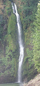
Rainbow Falls
Rating: ***
Form: horsetail
Magnitude: 85 (h)
Access: trail (page 236)
USGS Map: Linton Lake (1988)
White Branch Falls
Rating: **
Form: fan
Magnitude: 21 (l)
Access: trail (page 237)
USGS Map: Linton Lake (1988 nl)
Honey Creek Falls
Rating: *
Form: horsetail
Magnitude: 12 (l)
Access: trail (page 237)
USGS Map: Linton Lake (1988 ns)
Upper Falls
Rating: **
Form: segmented
Magnitude: 28 (l)
Access: trail (page 237)
USGS Map: Linton Lake (1988 ns)
Proxy
Falls
Rating: ****
Form: fan
Magnitude: 91
Access: trail (page 237)
USGS Map: Linton Lake (1988)
New Entry
Click Here for Terwilliger Falls (u), aka Rider Falls (u), USGS Cougar Reservoir (1989 ns) .
Format the page to match your hardcopy book by changing your printer settings to 9" x 5 3/4".
Others
Within Three Sisters Wilderness Area, trails are shown
on maps passing near Honey Creek Falls, USGS Substitution Point
(1988); Indian Holes Falls, USGS South Sister (1988); and Obsidian
Falls, USGS North Sister (1988). A distant roadside cross-canyon
view might be possible of Mosquito Valley Falls (u), USGS French
Mtn (1989 nl). Lack of accessibility is suggested for Linton Falls,
USGS Linton Lake (1988); Shadow Creek Falls (u), USGS Linton Lake
(1988 nl); Mesa Creek Falls (u) and Upper Mesa Creek Falls
(u), both USGS South Sister (1988 nl); and Separation Creek Falls (u), and Upper Separation Creek Falls
(u), both USGS South Sister (1988 nl).
Copyright 2008 by Gregory A. Plumb
GUIDEBOOK published by
Mountaineers Books